
This academic year (2013-14), I am the lead researcher for the Maker Lab’s “Z-Axis” project, which—in collaboration with the Modernist Versions Project (MVP)—is exploring forms of visualization that express subjective encounters with literary data through 3D modeling and prototyping. Stephen Ross (director of the MVP) describes this research as a combination of “literary analysis and desktop fabrication that allows us to ask how might our data be expressed, experienced, embodied, and felt.” As Stephen’s description suggests, our Z-Axis work is an interdisciplinary approach to literature that brings together established modes of analysis (e.g., close reading) with geospatial mapping and 3D sculpting techniques, allowing us to make arguments through new media about the intersections between text, space, time, and—to some degree—the subjective experience of reading.
The Z-Axis project relies on a modernist sort of remediation, which encodes, fragments, and distorts historical time and space in order to exhibit how cities (e.g., Paris, London, Dublin, and New York) are expressed differently in different modernist texts. In this sense, it sparks a comparative approach to literature and media. How, for instance, is Woolf’s London distinct from Conrad’s? From Bowen’s? And to what effects on our assumptions about modernist geographies? If you are interested in learning more about the core impulses of the Z-Axis initiative, then I recommend reading this post, by Jentery, from back in June.
Building on Jentery’s post, I think the best way to explain our Z-Axis work is to show you the first instantiation of the research thus far.
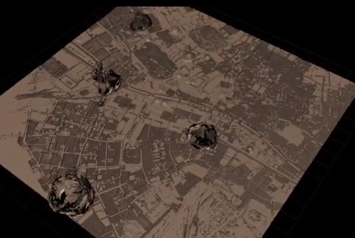
What you see above is a 1925 map of Dublin that has been scanned and transformed (using 3D modeling software) in order to consider a reader’s ostensible geotemporal experience of Dublin while reading Joyce’s Ulysses. The “mounds” in the map not only point to Joyce’s geospatial biases in the novel; they conjecture about how his version of the city might be read (consciously or not) by his audiences. In other words, they make no claim to isomorphic representations of Dublin. After all, the mounds are transformations of the base map itself, not data layered on top of it.
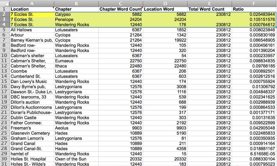
Above, you can see our data model for the word count per location. We did our best to figure out where, geographically, events were in the 1922 Shakespeare and Co. edition of the text. Then we did a word count to see how many words were spent in particular areas of Dublin. Next we divided the georeferenced counts by the total number of words in the book, giving us ratios for each area. So, for example, Joyce dedicates 30,262 words (or roughly 13%) of Ulysses to 7 Eccles Street. And once we tabulated all of this data, Alex Christie used Mudbox to accentuate areas on the 1925 map accordingly. This technique—which is at once algorithmic and manual—allowed us to create the mounds you see on the map.
Two things became clear during the early stages of this research. First, in Ulysses, the reader gets a very limited view of Dublin. Second, the reader is disproportionately located in just a handful of areas. That is, Joyce’s writing warps the city. It is, in a sense, already an act of transformation.
After we came up with this 3D model that embodies, if you will, a modernist distortion of time and space in Ulysses, Alex took the model one step further and began approaching Joyce’s warped Dublin from the street view (as opposed to the bird’s eye view provided above).
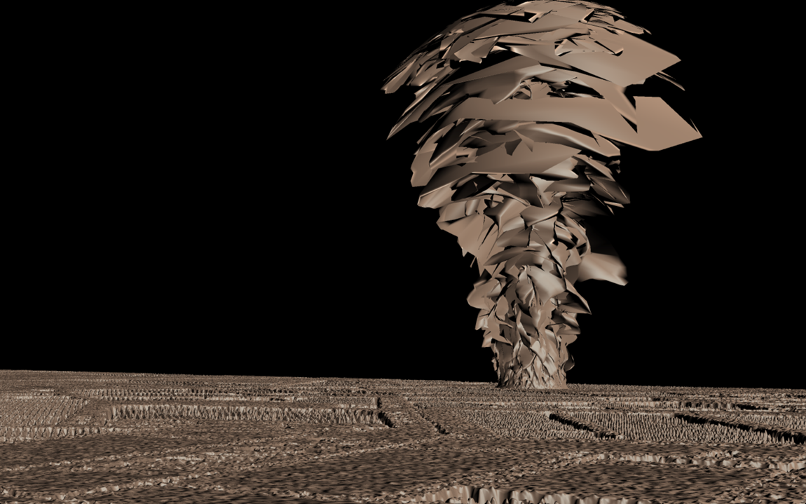
This view on the ground depicts grooves in the streets as well as the fragmented composition of the data mounds—tornado-like in their algorithmic expression, exhibiting a modernist (and even Cubist) aesthetic despite being born-digital. Through a shift in perspective, it also helps us better understand the need for depth in digital expressions, particularly those that are geospatial in character.
To be sure, we still have plenty of work to do along the z-axis of humanities research, especially where refining the model, replicating the method, and rendering print-ready prototypes are concerned. Nevertheless, this experiment has already prompted a number of exciting new research questions, anchored in how cities morph from modernist text to modernist text. Currently, we are replicating our approach through a turn to Paris, considering work by Hemingway, Rhys, Barnes, and Miller. And we plan to then move to London, perhaps with Conrad, Woolf, and Bowen. As we proceed, we are motivated by the claim that modernist cities are not static or objective entities. They are read, written, edited, embodied, and interpreted. Or put differently: Joyce used writing to transform the city, making it a medium for modernist expression. Ultimately, by comparing various versions of modernist cities, we can not only better understand modernist geographies but also bring modernist aesthetics to bear on current data visualization and 3D sculpting techniques, injecting digital scholarly communications with a conjectural take on everyday life.
Post by Katie Tanigawa, attached to the ZAxis Project, with the versioning and fabrication tags. Featured images for this post care of Alex Christie and Katie Tanigawa.
Pingback: Reading and Georeferencing Rhys | Modernist Versions Project()
Pingback: Maker Lab in the Humanities » University of Victoria » Reading and Georeferencing Rhys()
Pingback: Maker Lab in the Humanities » University of Victoria » The Maker Lab after Two Years()