
At MLA 2015 in Vancouver, I participated in the “Making as Method” panel, organized by the Division on Methods of Literary Research. Below is the text from my talk, which is based on research I’ve conducted with Alexander Christie, Stephen Ross, Kathryn Tanigawa, Adèle Barclay, and the Implementing New Knowledge Environments (INKE) and Modernist Versions Project (MVP) teams. Thanks to the MoLR Division, including Lauren Klein (who chaired the panel), for inviting me to contribute. I really enjoyed the panel, the talks by Kari and Mark, and the wonderfully engaging question-and-answer period.
Applying existing scholarship in media studies to literary criticism, today I will spend a few minutes discussing—to borrow from Bolter and Grusin—the remediation of fiction from 2D to 3D. To do so, I’ll draw examples from “z-axis” research conducted by the INKE-MVP research team at the University of Victoria, where a group of scholars, including Adèle Barclay, Alex Christie, Stephen Ross, Katie Tanigawa, and me, have warped historical maps with georeferenced word counts drawn from 20th-century novels, such as Djuna Barnes’s Nightwood (1936) and Jean Rhys’s Quartet (1928) and Good Morning, Midnight (1939).
To make the maps, we began with digitized novels as well as digitized maps—of Paris, for example—from their historical period. The novels were then parsed into geographic zones, based on urban areas prominent in their narratives. Of note, these zones were not identical in size. We did not, for instance, use a grid system. Instead, the organization of geographic space was based on its expression in the novels. With these zones operating collectively as a data model, Adèle, Katie, and Alex then encoded electronic versions of the novels with geographic data, informed in part by how the Map of Early Modern London—developed by our colleague, Janelle Jenstad, and her team at UVic—is encoded. Quite important here is the fact that our placement of geotags in the electronic text was ultimately an editorial decision. Rather than applying a fixed rule to the encoding process—say, systematically tagging each line or each sentence throughout a given novel—we decided to structure a text based on where in geographic space the narrative appeared to be taking place. As one may imagine, this was no easy task, and we frequently discussed the subjective character of this procedural interpretation, premised such as it was on literary (as opposed to literal) geography. Early on, we realized that we couldn’t always argue for the determinacy of our method, either. The results often depended quite heavily on who was doing the encoding when. At the same time, this honesty about encoding (as an editorial practice) was refreshing. It allowed us to unpack the different interpretations that emerged over time.
Once encoded, word counts for each geotag were gathered and used to alter the historical maps in a fashion resonating with McGann and Samuels’s deformance. Using a fixed ratio, this quantitative data was then applied to a 3D deformance technique in the digital sculpting software, Mudbox, where the maps were manipulated by hand. Here’s an example result, based on a geocoded version of Barnes’s Nightwood.
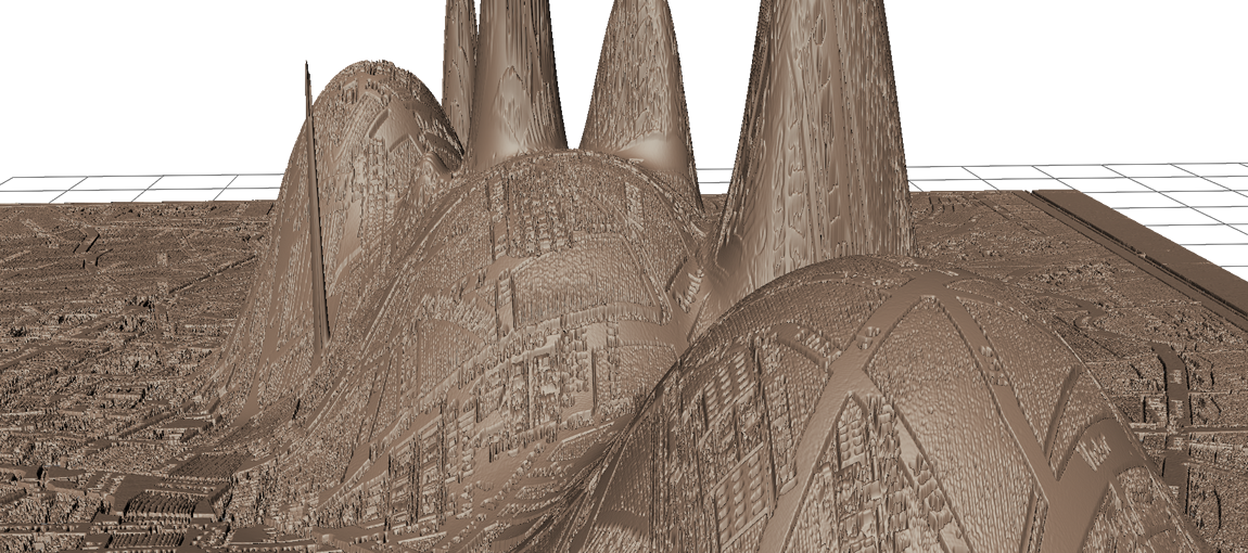
Visually, these maps put forth a claim that McGann and Samuels make in “Deformance and Interpretation,” namely that, through deformance, there is a “dramatic exposure of subjectivity as a live and highly informative option of interpretive commentary, if not indeed one of its essential features.” Based on our experiences thus far, audiences are more likely to wonder at the maps—at this exposure, at this subjectivity—instead of mobilizing them as instruments or guides for literary interpretation.
One might argue that the maps’ aesthetic is rather modernist, too. Like Dada, it resists utility and legibility, foregrounding noise or variation in a text. Against isomorphism, it reacts almost dogmatically to any rationalist treatment of space or language as objective and immediate. Comparable to numerous Futurisms, the maps also freeze social relations, expressing dynamics artificially. Here, Giacomo Balla’s “Plastic Construction of Noise and Speed” may be a precedent. In the z-axis maps, space is biased, value-laden, and even material. Warped, it is where—as Anthony Vidler suggests of art, architecture, and anxiety in modern culture—psychology and society collectively permeate form. The effect is a visualization that does not correspond neatly with any actual place, with any longitudinal or latitudinal coordinate.
This resonance with modernist aesthetics was in fact one of the aims of the z-axis project. That is, as a research team, we were interested in the degree to which digital or computational methods could rehearse creative procedures that were historically appropriate. In short, we wanted to use modernist aesthetics to interpret modernist aesthetics and, by extension, we speculated about whether, say, Victorian or Early Modern articulations of literary geography with computers may very well differ from ours, operating under distinct sets of assumptions about how space was constructed during specific moments in time. In this sense, making as method—or making the city in the work—was about giving historical texture to digital humanities methods and acknowledging that different texts call for different computational approaches, which may not be persuasive if applied uniformly across literary space and time.
However, making as method was not without its complications. First, the encoding process—again, using tags to mark geographic space in the text—often risked being too mechanistic, too literal a treatment of how literary geography actually operates. What’s more, the z-axis method could not consistently account for spaces off the maps at hand. These spaces include not only imaginary spaces but also peripheral urban areas or rural landscapes. They are the stuff of miscellaneous data that’s either excluded from graphical expression or assimilated too neatly into it. Consequently, while the encoding procedure afforded a focused surface reading, it did not lend itself well to ambivalence. And while the maps themselves are curious and quite evocative, we frequently wondered about the degree to which they could be used—if they should be used—by others for analytic purposes. Taken together, these points lead me to two important questions about making as method: first, to what degree should the scholarly output be instrumental? Where should it fall on the spectrum of, say, art and tool? From my experiences thus far, the z-axis project is curious in this regard because its data is computationally tractable while the 3D expression is not. Of course, this does not imply that neither is constructed. To be clear, both the data and its expression are quite cooked.
My second question about making as method is: What are the interpretive risks of re-enacting aesthetics of the past, no matter how aware or distanced we are from them? I raise this question because, even though the z-axis project was invested in highlighting the biases of authorial constructions as well as the subjective, affective, and embodied experiences of geographical space, the 3D visualization’s aesthetic corresponds with certain forms of the modernist avant-garde—namely Futurism—that make me (at least) rather nervous or apprehensive. That is, an investment in interpreting modernism through what we might call modernist computational methods made me feel too close to what Benjamin compellingly identified as aestheticizing politics. True, the z-axis research team can use the maps to demonstrate how, in Barnes’s Nightwood, popular areas in the Latin Quarter are fluid and permeable, whereas wealthy areas near the Champs-Élysées and the Opera are isolated and partitioned from each other. Or we can use to them to suggest that, while Barnes’s Paris is social and shared, Jean Rhys’s Paris in Quartet is a marginal Paris, a fragmentary and fugitive experience. However, these interpretations may not always be legible to others in the form of geotags, quantitative data, or 3D expressions. And the aesthetics of the visualizations may ultimately trump all the critical work that goes into them.
All of which suggests a wonderful irony about this particular experience: when using making as a method to actually construct the city in the work, I am left wanting to share my interpretations in the form of an essay, not data or a visualization. Perhaps this conclusion says more about my own biases and training than anything else. Still, with those of you in the room today I would like to discuss these implications of making as method, including the implications of humanities practitioners circulating non-textual objects for interpretation and even use. To what degree are non-textual objects a persuasive, standalone form of scholarly communication for literary studies? To what degree, and with what effects, are these objects enveloped by whiz-bang and wonder? And finally, how do we argue for immersion, rehearsal, or—if you will—“remaking” as a method resonate with (but not hostile to) critical awareness and reflexivity about our own procedures and positions?
Post by Jentery Sayers, attached to the ZAxis project, with the fabrication tag. Featured image for this post care of the INKE-MVP team and Djuna Barnes.